Datei:Expulsion map of the Circassians in 19th century.PNG
Zur Navigation springen
Zur Suche springen
Es ist keine höhere Auflösung vorhanden.
Expulsion_map_of_the_Circassians_in_19th_century.PNG (491 × 445 Pixel, Dateigröße: 15 KB, MIME-Typ: image/png)
![]()
Diese Datei und die Informationen unter dem roten Trennstrich werden aus dem zentralen Medienarchiv Wikimedia Commons eingebunden.
![]()
Beschreibung
| Beschreibung |
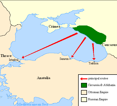
English: Map showing the location of Circassia and the expulsion routes (1859-1864) of the Circassians and other Caucasian peoples to the Ottoman Empire, after the Russian annexation of the North-Caucasus following the Crimean War of 1853-1856.
I used the information of the following two maps: http://www.circassianworld.com/CIRCASSIA1840.jpg And the books: The Northwest Caucasus: past, present, future, Walter Richmond The forgotten minorities of Eastern Europe, Arno TannerРусский: Карта с указанием местонахождения Черкесии и высылки маршрутов (1859-1864) от черкесов и других кавказских народов в состав Османской империи, после русской аннексии Северо-Кавказского следующие Крымской войны 1853-1856 гг. |
| Datum | |
| Quelle | Eigenes Werk |
| Urheber | DragonTiger23 |
Lizenz
| Ich, der Urheberrechtsinhaber dieses Werkes, veröffentliche es als gemeinfrei. Dies gilt weltweit. In manchen Staaten könnte dies rechtlich nicht möglich sein. Sofern dies der Fall ist: Ich gewähre jedem das bedingungslose Recht, dieses Werk für jedweden Zweck zu nutzen, es sei denn, Bedingungen sind gesetzlich erforderlich. |
Dateiversionen
Klicke auf einen Zeitpunkt, um diese Version zu laden.
| Version vom | Vorschaubild | Maße | Benutzer | Kommentar | |
|---|---|---|---|---|---|
| aktuell | 22:06, 5. Jul. 2013 | | 491 × 445 (15 KB) | Irānshahr | |
| 04:01, 4. Jul. 2013 |  | 491 × 445 (15 KB) | Irānshahr | Olahus is correct. | |
| 11:23, 3. Jul. 2013 |  | 491 × 445 (15 KB) | DragonTiger23 | Reverted to version as of 18:05, 11 February 2011 | |
| 15:23, 9. Dez. 2011 |  | 491 × 445 (15 KB) | Olahus | The Circassian inhabited region was actually much bigger. | |
| 20:05, 11. Feb. 2011 |  | 491 × 445 (15 KB) | DragonTiger23 | {{Information |Description ={{en|1=Map showing the location of Circassia and the expulsion routes (1859-1864) of the Circassians and other Caucasian peoples to the Ottoman Empire, after the Russian annexation of the North-Caucasus following the Crimean |
Dateiverwendung
Die folgende Seite verwendet diese Datei:
Globale Dateiverwendung
Die nachfolgenden anderen Wikis verwenden diese Datei:
- Verwendung auf bg.wikipedia.org
- Verwendung auf ca.wikipedia.org
- Verwendung auf it.wikipedia.org
- Verwendung auf ja.wikipedia.org
- Verwendung auf lmo.wikipedia.org
- Verwendung auf nl.wikipedia.org
- Verwendung auf pl.wikipedia.org
- Verwendung auf ru.wikipedia.org
- Verwendung auf ru.wikinews.org
- Verwendung auf sh.wikipedia.org
- Verwendung auf tr.wikipedia.org