Datei:Map Iran railways en.svg
Zur Navigation springen
Zur Suche springen

Größe der PNG-Vorschau dieser SVG-Datei: 695 × 600 Pixel. Weitere aus SVG automatisch erzeugte PNG-Grafiken in verschiedenen Auflösungen: 278 × 240 Pixel | 556 × 480 Pixel | 890 × 768 Pixel | 1.187 × 1.024 Pixel | 2.374 × 2.048 Pixel | 2.318 × 2.000 Pixel
Originaldatei (SVG-Datei, Basisgröße: 2.318 × 2.000 Pixel, Dateigröße: 7,15 MB)
![]()
Diese Datei und die Informationen unter dem roten Trennstrich werden aus dem zentralen Medienarchiv Wikimedia Commons eingebunden.
![]()
Beschreibung
| Beschreibung |
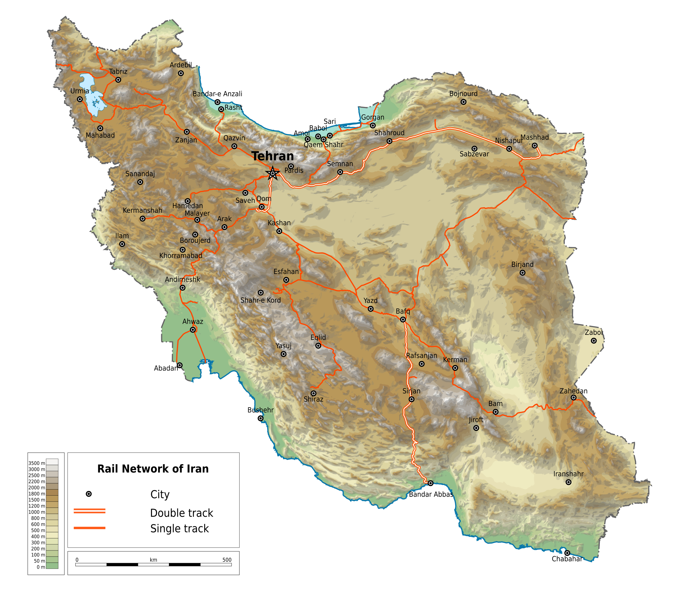
English: Map of railways in Iran (in English). Limits of the map:
|
| Datum | |
| Quelle | File:Map Iran railways fa.svg |
| Urheber | Ikonact |
| Genehmigung (Weiternutzung dieser Datei) |
Any use of this map is subject of the license(s) stated below with the condition that you credit (Wikimedia Commons user: Ikonact) as the author . A message with a reply address would also be greatly appreciated. |
| Andere Versionen |
|

Lizenz
| Dieses Werk enthält Informationen aus OpenStreetMap, die unter den Bedingungen der Open Database License (ODbL) bereitgestellt wurden.
Die ODbL erfordert keine bestimmte Lizenz für die Karten, die aus ODbL-Daten erstellt werden. Die durch die OpenStreetMap-Stiftung erstellte Kartenteile standen vor dem 1. August 2020 unter der CC-BY-SA-2.0-Lizenz. Karten von anderen Erstellern können unter anderen Lizenzen veröffentlicht sein. |
Ich, der Urheber dieses Werkes, veröffentliche es unter der folgenden Lizenz:
Diese Datei ist lizenziert unter der Creative-Commons-Lizenz „Namensnennung – Weitergabe unter gleichen Bedingungen 4.0 international“.
- Dieses Werk darf von dir
- verbreitet werden – vervielfältigt, verbreitet und öffentlich zugänglich gemacht werden
- neu zusammengestellt werden – abgewandelt und bearbeitet werden
- Zu den folgenden Bedingungen:
- Namensnennung – Du musst angemessene Urheber- und Rechteangaben machen, einen Link zur Lizenz beifügen und angeben, ob Änderungen vorgenommen wurden. Diese Angaben dürfen in jeder angemessenen Art und Weise gemacht werden, allerdings nicht so, dass der Eindruck entsteht, der Lizenzgeber unterstütze gerade dich oder deine Nutzung besonders.
- Weitergabe unter gleichen Bedingungen – Wenn du das Material wiedermischst, transformierst oder darauf aufbaust, musst du deine Beiträge unter der gleichen oder einer kompatiblen Lizenz wie das Original verbreiten.
Dateiversionen
Klicke auf einen Zeitpunkt, um diese Version zu laden.
| Version vom | Vorschaubild | Maße | Benutzer | Kommentar | |
|---|---|---|---|---|---|
| aktuell | 00:42, 29. Mär. 2020 | | 2.318 × 2.000 (7,15 MB) | Ikonact | == {{int:filedesc}} == {{Information |description={{en|1=Map of railways in {{W|Iran}} (in English). Limits of the map:}} *N: 40.229° N *S: 24.327° N *W: 42.517° E *E: 64.314° E Equidistant Cylindrical projection; WGS 84 datum |date=2019-03-28 |source=File:Map Iran railways fa.svg |author={{U|Ikonact}} |permission=Any use of this map is subject of the license(s) stated below with the condition that you credit (Wikimedia Commons user: Ikonact) as the author . A [http://c... |
Dateiverwendung
Die folgende Seite verwendet diese Datei:
Globale Dateiverwendung
Die nachfolgenden anderen Wikis verwenden diese Datei:
- Verwendung auf en.wikipedia.org
- Verwendung auf fr.wikipedia.org
- Verwendung auf hu.wikipedia.org
- Verwendung auf it.wikipedia.org
- Verwendung auf it.wikivoyage.org
- Verwendung auf ja.wikipedia.org
- Verwendung auf nn.wikipedia.org
- Verwendung auf no.wikipedia.org
- Verwendung auf ru.wikipedia.org
- Verwendung auf tr.wikipedia.org
- Verwendung auf zh.wikipedia.org