Datei:Northern Mali conflict.svg
Zur Navigation springen
Zur Suche springen

Größe der PNG-Vorschau dieser SVG-Datei: 629 × 600 Pixel. Weitere aus SVG automatisch erzeugte PNG-Grafiken in verschiedenen Auflösungen: 252 × 240 Pixel | 503 × 480 Pixel | 805 × 768 Pixel | 1.074 × 1.024 Pixel | 2.148 × 2.048 Pixel | 1.316 × 1.255 Pixel
Originaldatei (SVG-Datei, Basisgröße: 1.316 × 1.255 Pixel, Dateigröße: 796 KB)
![]()
Diese Datei und die Informationen unter dem roten Trennstrich werden aus dem zentralen Medienarchiv Wikimedia Commons eingebunden.
![]()
Beschreibung
| Beschreibung |
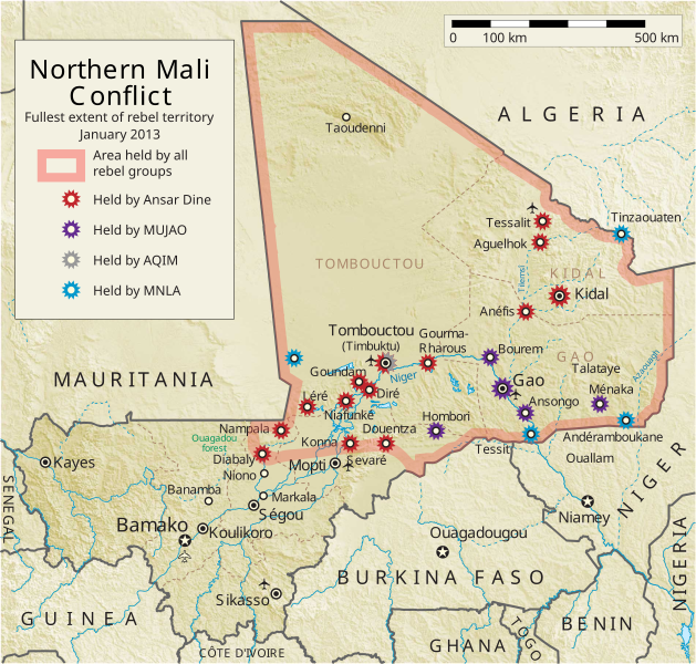
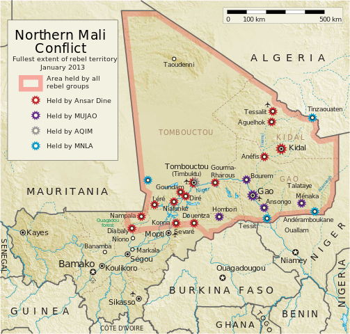
English: Map of the conflict in Northern Mali. (English)
العربية: خريطة الصّراع في شمال مالي. (إنجليزي)
Français : Carte du conflit au nord du Mali. (Anglais)
Latina: Charta rebellionis Tuaregorum in Malia septentrionali. (Anglice)
Українська: Карта конфлікту на півночі Малі. (Англійською) |
| Quelle |
Eigenes Werk Diese Datei enthält Elemente, die von folgender Datei entnommen oder adaptiert wurden: Diese Datei enthält Elemente, die von folgender Datei entnommen oder adaptiert wurden: |
| Urheber | Orionist |
| Andere Versionen | German/Deutsch/Allemand, French/Français, Macedonian/македонски јазик/Macédonien |
| SVG‑Erstellung |
Notes
- ↑ US Department of State, "Country Reports on Terrorism 2011", Chapter 2 Country Reports: Africa Overview, 31 July 2012
Lizenz
Ich, der Urheber dieses Werkes, veröffentliche es unter der folgenden Lizenz:
Diese Datei ist unter der Creative-Commons-Lizenz „Namensnennung – Weitergabe unter gleichen Bedingungen 3.0 nicht portiert“ lizenziert.
- Dieses Werk darf von dir
- verbreitet werden – vervielfältigt, verbreitet und öffentlich zugänglich gemacht werden
- neu zusammengestellt werden – abgewandelt und bearbeitet werden
- Zu den folgenden Bedingungen:
- Namensnennung – Du musst angemessene Urheber- und Rechteangaben machen, einen Link zur Lizenz beifügen und angeben, ob Änderungen vorgenommen wurden. Diese Angaben dürfen in jeder angemessenen Art und Weise gemacht werden, allerdings nicht so, dass der Eindruck entsteht, der Lizenzgeber unterstütze gerade dich oder deine Nutzung besonders.
- Weitergabe unter gleichen Bedingungen – Wenn du das Material wiedermischst, transformierst oder darauf aufbaust, musst du deine Beiträge unter der gleichen oder einer kompatiblen Lizenz wie das Original verbreiten.
Dateiversionen
Klicke auf einen Zeitpunkt, um diese Version zu laden.
| Version vom | Vorschaubild | Maße | Benutzer | Kommentar | |
|---|---|---|---|---|---|
| aktuell | 08:59, 8. Apr. 2014 | | 1.316 × 1.255 (796 KB) | Ansh666 | Reverted to version as of 16:51, 8 March 2013 - restoring the correct version, as the map is supposed to be historical, not current |
| 22:15, 5. Dez. 2013 |  | 1.316 × 1.255 (699 KB) | Hanibal911 | more accurately reflects the situation | |
| 18:51, 8. Mär. 2013 |  | 1.316 × 1.255 (796 KB) | Agricolae | Hombori dot restored | |
| 16:29, 5. Mär. 2013 |  | 1.316 × 1.255 (794 KB) | TUFKAAP | Since this is an English map, Al-Qaeda in the Islamic Maghreb should be abbreviated as AQIM. | |
| 05:33, 11. Feb. 2013 |  | 1.316 × 1.255 (794 KB) | Agricolae | shift text distorted on upload | |
| 05:27, 11. Feb. 2013 |  | 1.316 × 1.255 (794 KB) | Agricolae | change to show greatest extent - see WP Talk:Northern Mali conflict (2012–present) | |
| 08:36, 8. Feb. 2013 |  | 1.316 × 1.255 (699 KB) | Rama | Aguelhok contested or taken ( http://www.lemonde.fr/afrique/article/2013/02/08/mali-les-forces-francaise-et-tchadiennes-a-aguelhok_1828906_3212.html ) | |
| 12:29, 2. Feb. 2013 |  | 1.316 × 1.255 (698 KB) | U5K0 | Bourem to green as per talk page | |
| 10:41, 30. Jan. 2013 |  | 1.316 × 1.255 (679 KB) | Orionist | Updated map: Menaka, Anderamboukane, Ansongo, Dire, Kidal and other MNLA positions. Removed rebel area boundaries as the situation has become complicated. | |
| 19:23, 29. Jan. 2013 |  | 1.316 × 1.255 (894 KB) | Jaybear | Insertion of a map-scale in the upper right corner (added directly before the token "/svg" at end of svg-code); |
Dateiverwendung
Die folgenden 2 Seiten verwenden diese Datei:
Globale Dateiverwendung
Die nachfolgenden anderen Wikis verwenden diese Datei:
- Verwendung auf af.wikipedia.org
- Verwendung auf ar.wikipedia.org
- Verwendung auf azb.wikipedia.org
- Verwendung auf az.wikipedia.org
- Verwendung auf bg.wikipedia.org
- Verwendung auf bn.wikipedia.org
- Verwendung auf ca.wikipedia.org
- Verwendung auf cs.wikipedia.org
- Verwendung auf cy.wikipedia.org
- Verwendung auf da.wikipedia.org
- Verwendung auf el.wikipedia.org
- Verwendung auf en.wikipedia.org
- Mali
- Portal:Mali
- Insurgency in the Maghreb (2002–present)
- War on terror
- User:Orionist/Gallery
- National Movement for the Liberation of Azawad
- Wikipedia talk:WikiProject Maps/Archive 2012
- Wikipedia:In the news/Candidates/April 2012
- Wikipedia:Graphics Lab/Map workshop/Archive/Apr 2012
- Wikipedia:Wikipedia Signpost/2012-04-30/WikiProject report
- Wikipedia:Wikipedia Signpost/Single/2012-04-30
- Mali War
- Wikipedia:WikiProject Maps/Conventions/Pushpin maps
- Operation Serval
- Chadian intervention in northern Mali
- Islamist insurgency in the Sahel
- User:AlbanianEditor1990/sandbox
- Verwendung auf en.wikinews.org
- Verwendung auf eo.wikipedia.org
- Verwendung auf es.wikipedia.org
- Verwendung auf et.wikipedia.org
- Verwendung auf eu.wikipedia.org
- Verwendung auf fi.wikipedia.org
- Verwendung auf fr.wikiquote.org
- Verwendung auf he.wikipedia.org
Weitere globale Verwendungen dieser Datei anschauen.